
The first quarter-mile of Mt. Sherman’s Iowa Gulch trail is flat, meandering, and actually quite pretty. We made our way through creeks, willows, and mud, our vision blurry and limbs stiff. Soon, we were climbing upwards, pursuing the slender saddle connecting Mt. Sheridan (to the south) and Mt. Sherman. There were several on the trail; none moving as fast as we were. We made good time to the saddle, where the Iowa Gulch trail connects with the Southwest Ridge trail. There the crowds began in earnest. We staggered to the Sherman ridge, increasingly fighting the wind and falling temperatures. Finding the summit ridge amidst heavy clouds and wind, we pushed on to the false summit and, finally, true summit. Exhausted and relieved, we settled in behind some rocks to enjoy even a few minutes of the undeniable beauty spread out before us. The cold was unrelenting, however, so we set off for the return. It was a long, tired slog, though of course much faster going down than going up.Shuffling back to the willows and mud, we triumphantly made it to the truck, spent. Stop motion. Fist bumps. Triumph. Relief.
In previous years, we got an early start. This year, while my day certainly started early, we didn’t hit the road until 10:00 a.m. The going was unusually slow. Traffic, construction, and the fatigue of already having spent half a day at work made for a rather brutal drive. Clouds hung low through Nebraska, limiting the normally expansive sky to a confining, heavy blanket. Lunch, on the other hand, continued a rather normal, if uninspiring, pattern of fast food: McDonald’s in Kearney.
We pressed on, finally reaching the depressing eastern plains of Denver as the sun made its rapid descent in the western sky. Our hope was to reach Frisco by 7:00 p.m. for Thai chicken and beer at Outer Range Brewery, then on to set camp at Mayflower Gulch before dark. As we crept through Denver traffic, it was increasingly apparent that we would not reach our destination in time. In fact, we wouldn’t be close. Dusk settled in as we continued on I-70 through the foothills, Idaho Springs, the Eisenhower Tunnel, and finally Frisco. The sunset was impossible to discern for the dark clouds covering the valley. It began to rain as we parked and made our way into ORB, where we were promptly informed, “The kitchen closed twenty minutes ago.” Disappointment. By then, it was already 8:20 p.m., the rain was thickening, and we were tired and hungry. We ran across the parking lot to Pure Kitchen, where we were at the very least able to enjoy a spectacular chicken sandwich and beer. It got darker outside. The rain increased.
By 9:00 p.m. we were back on I-70, making our way to the Copper Mountain exit and, finally, the Mayflower Gulch trailhead. It was very dark. We drove up the deeply potholed 4WD trail, Mark shining his glitchy headlamp into the trees seeking a suitable campsite. The prospects were bleak, though perhaps just unseen as the small light barely penetrated the deep darkness and steady rain. After a couple possibilities were tested and aborted, we hit the end of the trail and backtracked, again finding nothing. Depressed, disappointed, and somewhat annoyed, we decided to continue on to Leadville in hopes of being inspired en route for where, exactly, to sleep. I should have stuck to my original plan of going to the Mt. Elbert trailhead dispersed campsites, but another 20 minutes of driving sounded terrible. Driving through Leadville, no cheery place anytime but especially depressing in the dark and gloom of a cool July night, we finally pulled into a cheap motel parking lot. The office door was locked, but Mark called the proprietress and asked for a room. She told us to wait: “I’ll be there in five minutes.” Alas, in those five minutes I determined that instead of cutting our losses and sleeping in a real bed (a wise, if perhaps soft option) we should press on to the Mt. Sherman trailhead and sleep in the truck. Exhausted, travel-fatigued, beset by thin air and insufficient oxygen to the brain, I didn’t know what I was suggesting. Mark, however, in his kindness, willingly agreed. We drove up to 12,000 feet, parked the truck, and settled in for the night.
To suggest that what we did in any way resembled sleep would be a gross exaggeration. Mark settled uncomfortably into the back seat of the cab. I rolled out my sleeping pad and bag in the covered truckbed. This claustrophobia-inducing bunk would perhaps have been suitable if, a) the truck didn’t reverberate with clamorous squeaks every time I moved my body, b) it was even a bit warmer than 40 degrees, and c) it was not raining. With my feet sticking out of the back, feebly covered with the tent footprint, rain smacking the truckbed cover, and my mind racing with the potential outcome of my poor decision-making (sleeplessness? hypothermia? wild animal snack?), I tried to settle in for anything resembling rest.
Alas, it was a futile exercise. I tossed and turned (very loudly) through most of the night, my feet increasingly wet and cold. Finally, I was able to sleep (mostly thanks to two sleeping pills), despite hideously weird dreams, and awoke supposing that it was nearly dawn. I looked at my watch—2:30 a.m. I think I cried a little bit. I was cold, uncomfortable, and generally feeling unwell (I’m never sick at altitude, but the first hours are usually accompanied by light-headedness and a general feeling of being out-of-sorts). After several more hours of tossing and turning (very loudly),I finally cut my losses and hopped into the cab—heat on; seat-warmer on. Resting my eyes and trying to relax, the sun finally emerged in a greasyeastern sky. It looked cold. As Mark came to, I retreated to the back of truck to prepare hot water for oatmeal and coffee. We ate, dressed, geared up, and set off in a fog of fatigue and cold.

| The warmth of the car was welcome as the sun came out and we descended the mountain into the quiet confines of Leadville. I was pleased to see that the town was buzzing with people and traffic. We parked on a side street and made our way to High Mountain Pies. Covid makes even lunch at a mountain dive into something of a tense affair. Masks on, we got in line (appropriately distanced from other customers), and soon ordered food: the Hawaiian pizza for Mark; a muffuletta sandwich and salad for me. Beers for both. We settled in at a table under mostly cloudy skies, the temperature a cool 65 degrees, and enjoyed our fantastic repast. I remain convinced that HMP’s secret is in infusing the pizza crust and/or sauce with THC. I will have to be convinced otherwise. |
Fully sated, we set off to explore a bit of downtown Leadville: second-hand gear; intel on good hikes in the area (bemused by the bike shop proprietor with the curious accent and sheepish confession, “I don’t like people”); the sleepy stoner at Floyd’s of Leadville who reminded us why marijuana is best left alone; and finally the drive to Half Moon Creek. There, under threatening skies, we set up camp in a lovely spot just as the rain began to fall. Finally…rest.
Later in the evening, the clouds parted enough for us to explore on foot for a bit. We debated our plan for Saturday morning, finally deciding to do a reconnaissance of the North Half Moon Creek trailhead, which would ostensibly lead us on the Southwest Slopes trail to the pinnacle of Mt. Massive. This seemed a rather ambitious plan after the long drive, pitiful night of sleep, and ascent of Mt. Sherman. The 4WD road to the trailhead was exceptionally rough, but fun to drive. Thirty minutes later, we found the trailhead and confirmed our plan to attack Massive in the morning.
Back at camp, we built a fire (much to the consternation of a neighbor), prepared dinner, and settled in for a quiet evening. In the course of our discussions about the morrow, we determined that there were likely three options: 1) if raining in the morning, we would beat a quick retreat to Denver and the hotel awaiting us there; 2) if clear, revived by a good night of rest and iron determination, we would make the drive to the Southwest Slopes trailhead of Massive and undertake the rigorous climb of Colorado’s second highest peak (14,428 feet); or 3) if clear, in anticipation for what we expected to be an intense couple of days in RMNP, we would take an easier path and simply meander north on the Colorado Trail.
We were up early (3:30 a.m.), having slept reasonably well and delighted to be met with no rain. Donning our gear, we quickly determined that Massive might be too ambitious of an undertaking. So, after a brief pitstop to relieve our bowels, we made our way to the Mount Massive East Slopes trailhead, parked, and set out on the Colorado Trail. It is always a special joy to hike through the mountain woods in the dark. The steady, but not taxing, climb brought us through aspen and pine groves, across streams, nominally lit by the early morning light of the eastern sky. As the sun rose, we forded North Willow Creek and the Mount Massive junction, continuing north into subalpine meadows and brilliant vistas of Turquoise Lake. Eager to break camp and enter into the next chapter of our odyssey, we retraced our steps, the woods now illuminated by the early morning summer sunlight, exposing a few campsites but otherwise few signs of life outside of trees, birds, and occasional ground squirrel. It was a pristine, classic hike and perfect way to stretch our legs in recovery from the rigors of the previous days.
Back to our campsite by 8:00 a.m. (after having hiked a brisk 8 miles), we quickly broke camp with the skill and efficiency of a NASCAR pit crew. By 9:00 a.m. we were packed up and set out. The day was shaping up to be similar to the days before: mostly cloudy with a threat of rain. Driving north on Colorado 91, I was again struck by the beauty and wildness of the Sawatch Range. It was a glorious drive, accompanied by U2X on Sirius radio and the impending promise of civilization. After a quick stop in Frisco for Starbucks coffee and breakfast sandwiches (I love Frisco), we continued east on I-70 for Denver.
As we had several hours before check-in at the hotel, and needing to stock up on a few supplies, we traveled directly to the Denver REI flagship store on Platte. A glorious Saturday morning in Denver, we were met by hordes of others who were out and about doing the same as us: enjoying a beautiful day, stocking up on outdoor gear, or just exploring the Commons Park-Highland neighborhood of Northwest Denver. We navigated the huge store—I purchased some climbing gear (nuts, quick draws), freeze-dried food, and Honey Stinger waffles—and then found a place to park down Platte Avenue. We lunched at Superfood Bar (smoothie for me; quinoa bowl for Mark), and then we each set off to explore. I bought a pair of pants at Royal Robbins (which I’ve already deemed the best pair of pants I’ve ever owned, to which one might respond in considering the $85 price tag, “I sure hope so!”).
Reunited, we set out for Golden and the hotel. There, we set out our soggy tent and hammocks to dry before occupying our room. While Mark completed his ablutions, I sat by the pool for my devotions and journaling, keeping a wary eye on the storm clouds moving in from the south. As the first raindrops began to fall, I made my way to our room and the welcome luxury of a hot shower (surely one of the top five shower experiences of my lifetime). Clean, refreshed, and of absolutely no surprise to our wives who would insist that we cannot sit still, Mark and I decided to head to Boulder well ahead of our 5:30 p.m. meeting time with Luke and Jane.
As we drove to Boulder, the deluge commenced. Lamenting our saturated camping gear, and hoping it would not be stolen as it laid on a grassy knoll beside the hotel parking lot, we drove up Colorado 93 to find the Flatirons and city of Boulder awash in sunlight. Parking just off of Pearl Street, we made our way to first reserve a table at West Flanders Brewing Company and then peruse the wares on the pedestrian mall. It was a lovely, sunny, busy Saturday night in Boulder, and a perfect evening for strolling along Pearl Street. It has been disappointing, however, to contrast my early memories of Pearl Street with my experiences over the last couple of decades. Back in the 1980’s, Pearl Street was filled with hippies, Moonies, druggies, musicians, street performers, bored local kids, and families vacationing. It was a blast to get a nose-full of dope, find a cheap touristy tee-shirt, and watch BMX performers in front of the courthouse. Today, Pearl Street is filled with a random Deadhead or two, but mostly with Patagonia-wearing super athletes, woke university students, soccer moms, and small groups of men from Texas. I miss the old days.
Despite all that, there was no place I would rather be than Pearl Street on a Saturday night in July. We met Luke and Jane for dinner—burgers and beer at West Flanders—and then hit Boulder Books and a couple of tourist traps for a) Jon Krakauer essays, and b) a tank top for Julie. By 8:00 p.m., we’d had enough, and retreated to Golden for luxurious rest in a real bed without the threat of rain and cold. Arriving back at the hotel, however, we were confronted with a more immediate challenge: how do we dry out our now-saturated tent? Mark, the genius, devised a plan by which our gear was dried in our room, using only tent poles and the basic laws of thermodynamics. Our gear nicely drying, we retreated for bed and the only good night of sleep we would have all weekend.
Sunday morning found us awake at 7:00 after a full night of rest. We were elated to find our gear dry. After a quick breakfast and collection of gear, we set out for Estes Park, stopping at a nearby Starbucks to supplement our meager hotel fare with real coffee and breakfast sandwiches. The Colorado Sound on the radio, we made our way through the foothills on Colorado 36 to Estes Park, arriving at the Beaver Meadows Visitor Center at 9:30 a.m. to pick up our backcountry permit and reservation.
Permit in hand, we made our way to the parking garage and Starbucks to await Luke’s arrival. I probably should have eaten real food at this point, but I was nervous. Would the weather hold? Could we make the hike laden with 40 pounds of gear each? Would there be space in the Boulderfield? Would we be warm enough in the night (snow was forecast)? How terrifying would the Northwest Couloir Route be? Would it be dry? Passable? I sipped a smoothie as we waited, and then hit the men’s room in the visitor center one last time before meeting Luke. He rolled in at approximately 11:00 a.m., prompting us to do a final gear check, suit up, and pack up before heading to the trailhead. We drove the short, pretty 8 miles to the Longs Peak trailhead, arriving just before noon to overcast skies and pleasant temps. Loading up, we slowly made our way to the trail, stopping briefly to chat with Park Ranger Derald DeYoung (originally from Grand Rapids and former Calvin College music instructor) before starting up.
On the trail, we settled into a pleasant rhythm through the trees, arriving at Goblin’s Forest (1.5 miles in) in less than an hour. This seemed to be auspicious, as I was feeling good and the pack weight was not terrible. We continued to climb, the trail continuing upward, but at a pleasant rate of elevation gain. Soon, we were climbing by Jim’s Grove, through the alpine tundra of Mills Moraine, and finally to the Chasm Lake junction at mile 4.5. We were pretty well knackered at this point, fighting tedium and intermittent rain as low clouds covered the east face of Longs Peak. We still had 1.7 miles to go. The novelty of the hike had worn off, the rain persisted, and Mount Lady Washington blocked easy passage to our destination. The worst part about the East Long’s Peak trail at this point is that it meanders above the tree-line almost interminably, winding all the way around Mount Lady Washington and finally through Granite Pass (Battle Mountain taunting us to the north), at which point we could at least smell the Boulderfield.
A final half-mile slog brought us at long last and with great relief to the Boulderfield, where we found a campsite, set up the tent (in the rain, of course), changed into dry clothes, and rested in the warm, mostly dry confines of the Mountain Hardware Trango 3 bomb-shelter eating Mike & Ike’s, thanking God for reaching our destination, and praying that the rain would soon relent. As I read Krakauer and dozed, I soon noticed that the inside of the tent was much brighter and I could no longer hear the gentle pitter-patter of rain on the fly. Mark peeked outside. The skies had cleared, the sun had come out, and it was suddenly a bluebird day. Overjoyed, we all ran out to lay out our clothes to dry, to soak up the sun, and to marvel at the imposing east face: the Diamond.
As Mark settled into a comfy spot on a large boulder, mesmerized by the spinning clouds above the Keyhole, Luke and I took off towards the ridge leading up to the east face. Hopping over boulders is always a blast in the Boulderfield, and we were soon peering down into the abyss at Chasm Lake in the distance to our left, the east face rising up dramatically, forbiddingly, to our right. We snapped a few pictures, gaped in awe at the Diamond, and eventually beat a hasty retreat to the sunny safety of our campsite. As dinner was prepared—Sante Fe chicken and rice for Mark; fettuccini alfredo for Luke; Indian curry for me—we discussed our plan for the next day: optimistic that the weather would hold, should we go up the Northwest Couloir Route or, in a slight twist suggested and gently pressed by Luke, ascend via the old Cables Route? The Cables Route is a classic Longs route up the north face along a series of old eyebolts that at one time carried a cable that most climbers used to ascend Longs. The National Park Service got rid of the cable a long time ago, but the eyebolts remain as stable anchoring points for a traditional alpine ascent. Luke was clearly in favor of the technical 5.5 Cables Route. Mark and I had been planning on the more modest 5.0 ascent up the Northwest Couloir, which seemed like the next step in our climbing evolution beyond the 3+ Keyhole Route. Even looking at the Cables Route up the north face, where a fall would be deadly and ultimately end in an 800-foot free fall off the Diamond, the Northwest Couloir seemed like the wise, responsible thing to do. The Cables Route would be there next year. Besides, I reasoned, if we got up and down the Northwest Couloir/Keyhole Route quickly in the morning, we could always give the Cables Route a shot in the afternoon (not realistic thinking, but it was my way of not having to make a decision about the Cables Route, however attracted/intrigued/exhilarated I was). Luke and I visited with some neighbors about their proposed route, finding that they were uncertain, as well, aside from having some photographs and the basic direction of the Cables Route. I was again intrigued, though it still felt a bit far-fetched. Back at the tent, we decided to sleep on it and decide in the morning, trusting that whichever way we got up the mountain, it would be a challenge and a joy.
The guys turned their lights out while I continued with Krakauer. I finally turned my headlamp off just as the stars began to come out. It was mercifully warm in the cozy, albeit malodorous tent. I drifted off to sleep. My early morning bathroom break brought me out to a summer night sky filled with twinkling jewels. As I looked to the northwest, falling stars littered the horizon. The lights of Denver shone to the east. It was calm and clear. Stoked, I crawled back into my sleeping bag excited about the day ahead.
The hikers made their presence felt as early at 4:00 a.m.—crunching over boulders, talking, their headlamps bobbing in the early dawn. By 6:00 a.m. I was up boiling water for coffee and oatmeal. We continued our discussion from the night before as we downed our breakfast and began to gear up. My bowels coming to life, I excused myself, saying, “We will make a decision when I return.” Taking a crap at 12,500 is a bit of an undertaking. Thankfully, the national park service thought of this, placing two well-appointed commodes fifty yards from our campsite—complete with toilets and stunning views of Battle Mountain. As I sat, I reviewed a part of my dream—a dream that included me sitting on a high vista above the trees, the fear of falling imminent, and the eventual breath-taking plunge into God-knows-what. It occurred to me, “Face your fear.” Walking back to the guys, carrying the tie-breaking vote, I said, “Cables Route.”
We geared up: water, food, harnesses, rope, hardware, helmets, extra layers. Gingerly making our way through the Boulderfield south and west to Chasm View, we stopped briefly to peer over the edge, a vertigo-inducing glimpse into the abyss and the fear that gripped me. Identifying the first eyebolt, we put on our harnesses and made our way up. I belayed as Luke lead-climbed up the first pitch, setting protection and making the route look relatively easy. After anchoring to the next eyebolt at the top, Luke downclimbed to us, at which point Mark and I made our way up. It was harder than it had looked. I quickly got shaky in my limbs and carefully considered my mortality, trying to discern whether or not a tumble from my tenuous position would be arrested before I hit the edge of the Diamond. Powering on, we all made it up the first pitch. I was exultant. As we prepped the second pitch, I noticed my surroundings: it was a perfect, windless, bluebird day in one of the most beautiful places on the planet. I was with friends. I was climbing.
We more nimbly navigated the second pitch, finally arriving at 13,000 feet with the hardest work behind us. Packing our rope and hardware away (on Luke), we scrambled up the last one-third of the route to the airy summit of Longs, attracting the admiring glances of Keyhole Route climbers who wondered where in the world we had just come from. After we snapped pictures, explored, and congratulated each other, Luke made a pot of coffee while Mark & I relaxed and made friends with the hippies who had just come up the Keyhole Route. They shared their figs and date bars and pulled out an old portable television (driven, as they were, by the idea of watching Mexican soap operas at 14,000 feet); we shared our chocolate, cashews, and coffee. It was a triumphant day on the mountain.
Far too quickly, we decided we best head down, as storm clouds were beginning to form towards the south. Packing up our gear and finishing our snacks, we made our way to the north face, where we pulled out our ropes and hardware and Luke gave us a crash course in rappelling. I can’t say that, beyond a few tense moments, I was ever terribly scared going up. As I leaned back on the rope to begin my first rappel down, however, I was suddenly terrified. What if my hands slip? What if the anchor doesn’t hold? What if the rope snaps? What if my hardware or harness malfunctions? A fall here would most certainly be fatal.
The first rap went as hoped—smoothly and without incident. We regrouped for a moment as the storm clouds continued to build, and soon completed the second rap…and the third and final rap. Elated to be down, now racing against time, we packed up our gear and raced down to our camp, arriving just as the rain did. Resting our tired limbs and minds for just a moment, we decided to break camp and head all the way down, the thought of another night in a tent almost unbearable. In record time we broke camp and packed up, setting off down the East Longs Peak Trail at 1:00 p.m. after an extremely full morning on the mountain.

If you want to make lasting friendship, climb together. 
The shark fin, looking up the cables route. 
Sundown in the Boulderfield. 
A wee bit chilly on the summit of Sherman.
 |
| Take a deep breath... |
 |
| Triumph! |
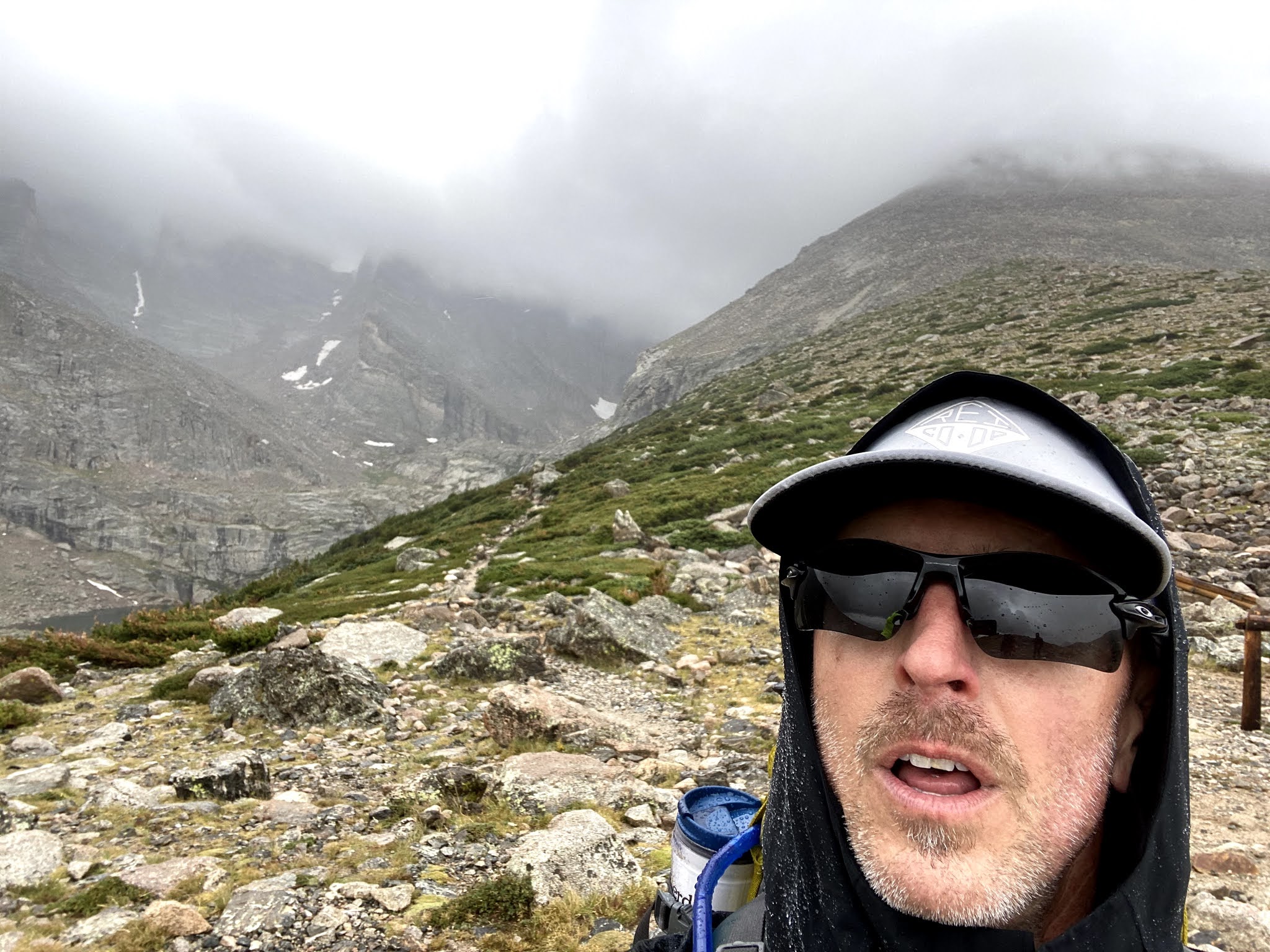 |
| The novelty has worn off... |
 |
| On our way to Chasm View and the Cables Route. |
 |
| Sums it up pretty well... |
 |
| Mark rappelling down the north face of Longs Peak, RMNP. |
 |
| A few moments before gearing up... |
 |
| The Sioux County Alpine Club representing on Longs Peak trailhead. |
 |
| Trying to dry out in the San Isabel National Forest. |
 |
| Gearing up for the climb up... |
 |
| A bluebird day in the Boulderfield. |
 |
| A quick rest on the way up Sherman. |
No comments:
Post a Comment